Rae Copper Silver Project
Nunavut, Canada
A Tier-one high-grade Canadian copper discovery with district-scale and sedimentary hosted upside.
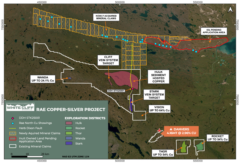
The Rae Copper Silver Project is White Cliff Minerals’ flagship Canadian asset, located on mainland Nunavut approximately 75 km from the town and deep water port of Kugluktuk. The project covers an area of approximately 2,000 km² and is situated within a highly prospective copper district that hosts multiple known copper occurrences and discoveries.
Rae combines near surface high grade copper mineralisation with district scale sedimentary hosted copper potential. This unique combination underpins White Cliff’s strategy to pursue near term development opportunities while systematically advancing larger scale exploration targets capable of supporting a material copper project.
Danvers Copper Silver Discovery
Danvers represents the most advanced discovery within the Rae Project and provides a clear pathway toward a maiden resource. The deposit hosts a historic resource of 4.16 Mt at 2.96% copper and has been materially expanded through recent drilling programs.
Drilling has confirmed broad zones of copper and silver mineralisation extending from surface, with mineralisation remaining open along strike and at depth. Recent results have demonstrated continuity well beyond historic drilling limits, highlighting significant upside potential.
Rae Project Area
Key Highlights:
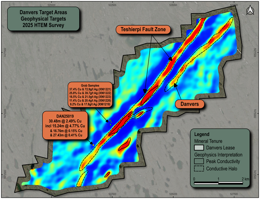
Danvers – 2025 Drilling Results
Rae Copper-Silver Project spans more than 1,200 square kilometres in one of the world’s leading mining jurisdictions Nunavut, Canada. A short flight from the regional mining hub of Yellowknife and around 75 km from the coastal town of Kugluktuk.
The 2026 regional campaign is systematically drill-testing roughly 12,000m of lateral strike along the Teshierpi Fault Zone, the major mineralised structure running through the Danvers area, where visible copper sulphides have been logged in every hole drilled into the main structure and the system has now been traced across more than 4.1 km of strike, remaining open in both directions.
Map of 2026 RC drillholes in the SW of the Teshierpi Fault Zone. Basemap of EM anomalism (X component) from 2025 geophysical survey. Interpreted mineralization trend highlighted by white outline between the observed downhole intervals of copper sulphides.
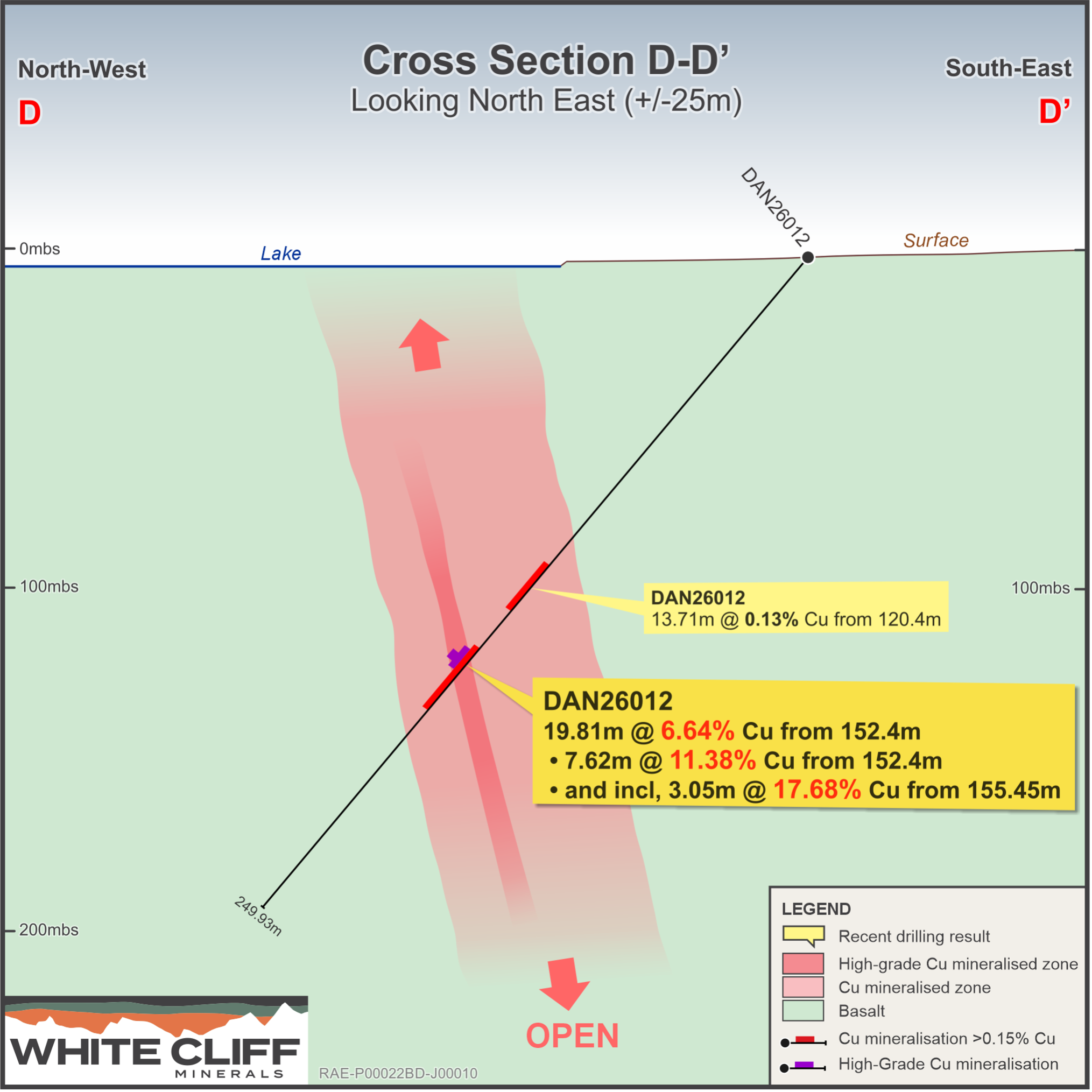
Cross section of drillhole DAN26012 located within a major EM anomaly that follows the Teshierpi Fault Zone. Extraordinary copper grades were returned from this newly discovered mineralisation.
Dual Pronged Growth Strategy
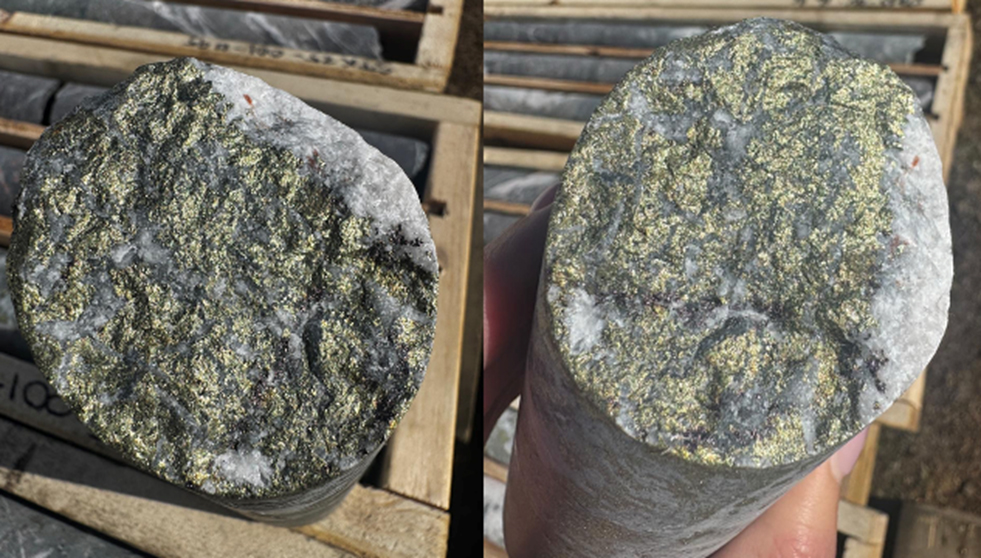
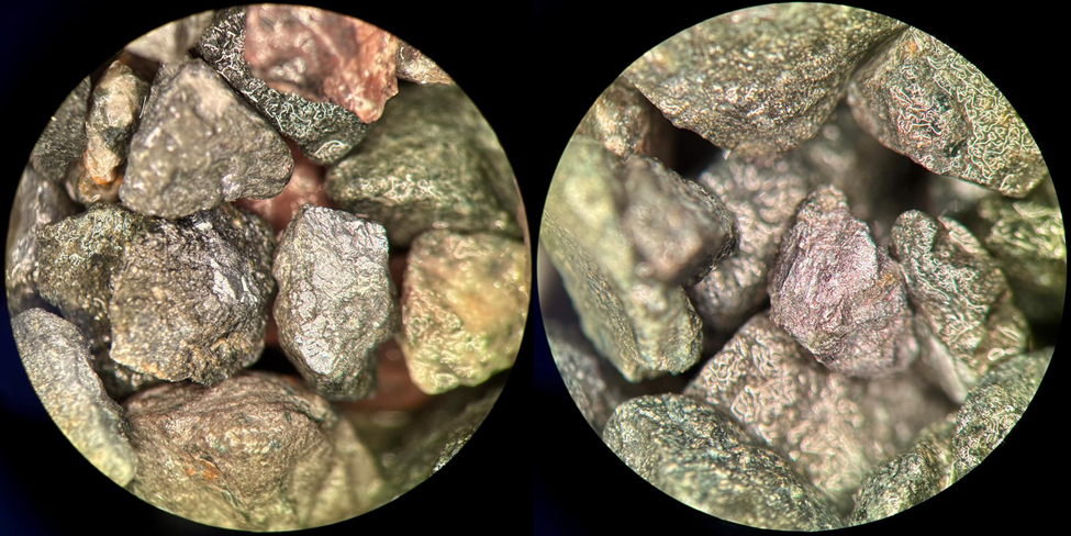
Chalcopyrite-bornite-quartz-carbonate veining below the base of the sedimentary structure in STK25001 at 291.4m that returned assays of 14.95% Cu & 0.51g/t Au. Core diameter is NQ2
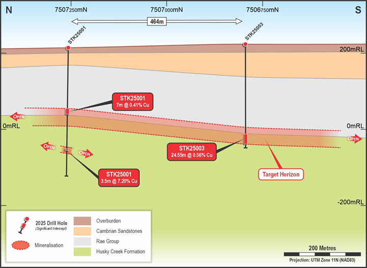
Sedimentary Copper Targets
Initial drilling at sedimentary targets has intersected broad zones of copper mineralisation across multiple holes. Mineralisation has been confirmed both above and below the targeted redox boundary, an important control for sedimentary hosted copper systems.
Large areas adjacent to initial drill holes remain untested and represent immediate follow up targets with potential to define a materially larger copper system.
Regional Targets – Hulk and Stark

Access and Infrastructure
Rae is well located from an infrastructure perspective. The project lies approximately 75 km from the town and deep water port of Kugluktuk, providing access for bulk materials during the open water season.
The project area is serviced by an all weather airstrip enabling year round access. Operational and logistical support is provided from Yellowknife, an established mining hub located approximately 90 minutes away by flight.
Development pathway and next steps
TIMELINE:

Dash 7 aircraft on the Company’s all weather air strip

Town and Port of Kugluktuk, only 75km from the Rae Copper-Silver Project

Industrial town of Yellowknife only 90 minutes by flight